TerraBytesGEOPHYSICAL SURVEYING

TERRABYTES / TECHNOLOGY

Four technologies.
One integrated platform.

Explore our principal technologies. Each is developed for practical field work, from autonomous instrument deployment and GNSS-linked recording to operational supervision and scientific data processing. The WiFi Hub connects instrument data, GNSS positioning and field communications within the TerraBytes survey system.

01 / FIELD ROBOTICS

GridRunner

Autonomous survey vehicle
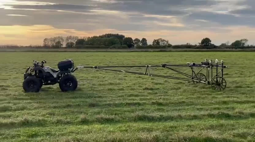
Actual TerraBytes GridRunner quad towing a long multi-sensor geophysical survey array across a field View full image

GridRunner in field operation · TerraBytes survey platform

AUTONOMOUS ACQUISITION

Precision movement for repeatable survey work.

GridRunner is our electric all-terrain survey vehicle. TerraBytes guidance software follows planned survey traverses using centimetre-class RTK GNSS positioning, with controlled survey speed and consistent track spacing to support reliable instrument acquisition.

The vehicle operates with a towed magnetometer array, while the field operator supervises guidance, positioning, speed, instrument status and survey coverage through Operations Centre.

Guidance and positioning

RTK-guided path following, planned traverses, AB alignment and repeatable survey runs.

Vehicle control

Operator-selectable speed, selectable 2WD/4WD drive and managed end-of-line U-turns.

Survey integration

Towed geophysical arrays, sensor swath configuration and coordinated data collection.

Operational safety

Operator oversight, physical stopping arrangements and developing software fault responses.
02 / FIELD COMMUNICATIONS

TerraBytes WiFi Hub

Integrated communications, positioning and data logging

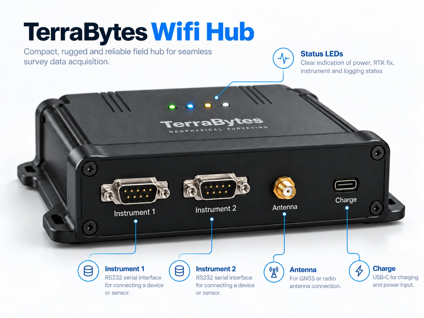
TerraBytes WiFi Hub enclosure concept with Instrument 1 and Instrument 2 serial connections, GNSS antenna connection, charging port and status indicators View full image

Integrated field communications hub · enclosure concept

ACQUIRE / POSITION / RECORD / TRANSMIT

The communications and logging centre of the TerraBytes field system.

The TerraBytes WiFi Hub connects our geophysical instruments to the rest of the survey system. It receives live measurements from compatible sensors and combines them with position information from its onboard GNSS receiver, keeping instrument readings and location data together as fieldwork progresses.

Each incoming measurement can be logged with its corresponding time and XYZ coordinates. Where RTK corrections are available and the GNSS receiver achieves an RTK fix, the positioning data is recorded with full RTK accuracy. The combined instrument and positioning stream is also sent over Wi-Fi to Operations Centre, where the field team can monitor acquisition and identify interruptions. The TerraBytes field monitoring interface is accessible on smartphones and laptops.

Receive instrument measurements

Collect data from compatible geophysical instruments as the survey proceeds.

Record positioning with data

Associate instrument readings with onboard GNSS measurements, timestamps and XYZ coordinates.

Send live data to Operations Centre

Pass the instrument and positioning stream over Wi-Fi for field monitoring and quality checks.

Monitor acquisition health

Indicate power, GNSS fix, instrument activity and logging state so faults can be identified promptly.

03 / FIELD OPERATIONS

Operations Centre

Live oversight and survey control

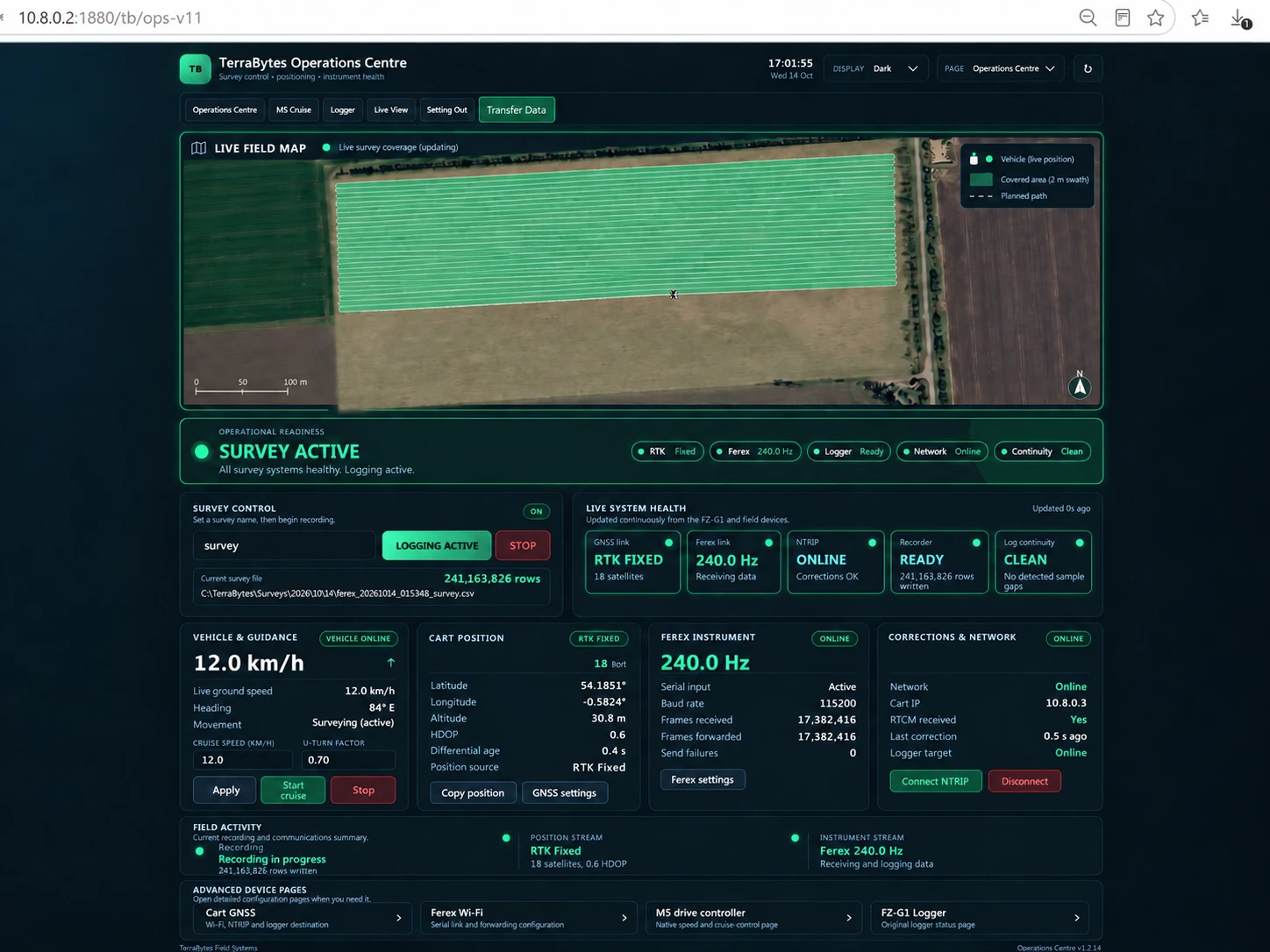
TerraBytes Operations Centre survey dashboard showing live geophysical coverage, vehicle telemetry and system status View full image

Operations Centre · survey control and monitoring view

MONITOR / CONTROL / REVIEW

One operational view of the vehicle, instruments and survey.

Operations Centre brings together the live vehicle position, RTK positioning status, instrument health, acquisition rates, coverage map and operator controls. Field staff can see the state of the survey while it is being acquired, rather than discovering missing sections later.

Acquisition interruptions and other faults are identified, reported and recorded for review. The planned gap-recovery workflow allows the operator to authorise reacquisition of missing sections when conditions are safe and positioning and logging services are healthy.

Live monitoring

GNSS, sensors, logging continuity, vehicle status and live survey coverage.

Operator control

Survey and vehicle control interfaces, speed selection and supervised stopping.

Fault reporting

Visible alerts, event history and identification of coverage or data-quality gaps.

Records and review

Reviewable coverage and acquisition records, with operator-authorised recovery tools in development.

04 / SCIENTIFIC SOFTWARE

R-12

Processing, interpretation and reporting

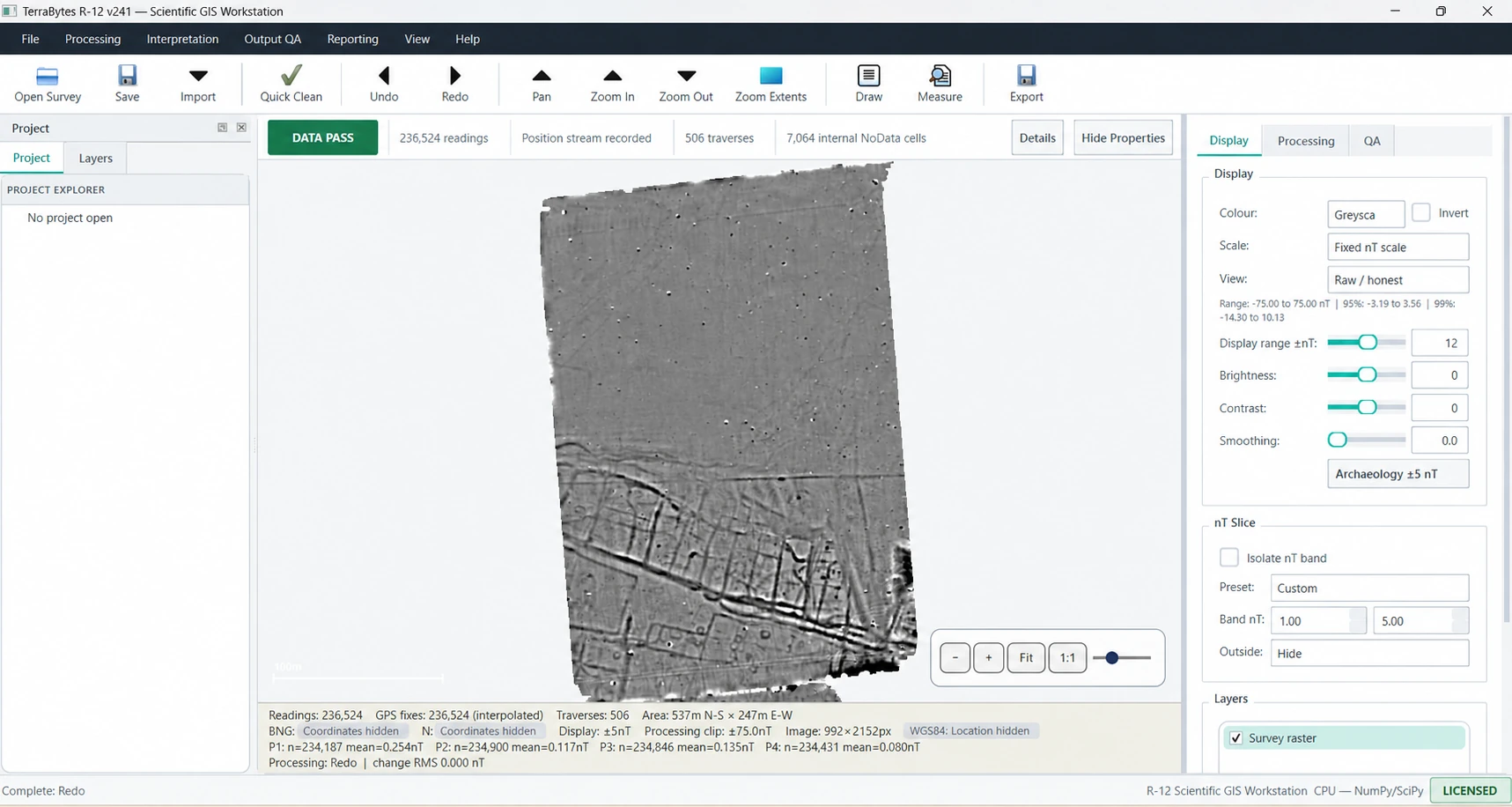
R-12 scientific GIS workstation showing a processed grayscale magnetometry map, processing controls and analysis options with location coordinates concealed View full image

R-12 scientific workstation · survey coordinates concealed

GEOPHYSICAL DATA / AI-ASSISTED ANALYSIS

From recorded measurements to interpreted survey evidence.

R-12 is our in-house geophysical processing and interpretation software. It supports instrument-data import, traverse review, cleaning, correction, gridding, georeferenced visualisation and preparation of coherent survey datasets.

AI-assisted feature identification supports expert review rather than replacing archaeological judgement. Users can mark and annotate anomalies, prepare coordinates for field setting-out, and assemble professional reports and GIS-compatible outputs.

Processing and QA

Data validation, directional corrections, de-duplication, artefact removal and gap repair.

AI-assisted interpretation

Feature identification and interpretation layers for subsequent human review and editing.

Feature marking / setting out

Mark selected anomalies, record target coordinates and navigate to them using GNSS guidance.

Deliverables

Interpretation maps, georeferenced GIS outputs, structured reports and Full Data Packages.

EXPLORE TERRABYTES

See the outputs from our survey workflow.

See what goes into a TerraBytes client data package.

View deliverables →